

With the flight restrictions that were placed on pilots that prevented them from flying over the construction zone ( shortly after I posted these aerial pics ) removed, new photos of some pretty interesting conditions on the north bank construction of Site C are again raising concerns. ( photo credit to Don Hoffman)
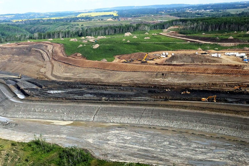
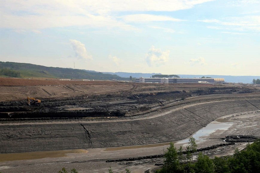
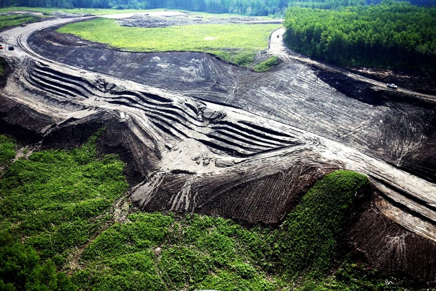
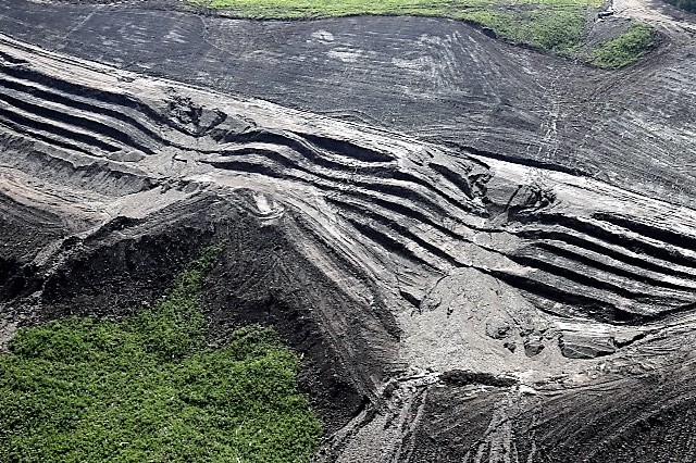

Hmmm.. The Peace river region has been experiencing some torrential rains this summer, with several major storms causing flooding in the area.And while the weather may change as time goes on, the type of soil and soil conditions, will not.
One can’t help but wonder… is this what happens when you build a dam on ” sedimentary shales surrounded by slippery clays.”? Or is this just what happens when you try to get to the point of no return in an area with known geotechnical challenges?
A recent letter sent to
July 16, 2016
Honourable Mike Morris Honorable Mark Garneau
Solicitor General & Minister of Public Safety Minister of Public Safety
Parliament Buildings, Parliament Buildings
Victoria BC Ottawa, Ontario
V8V 1X4 K1A 0A6
RE: Site C – A Public Safety Hazard
Dear Sirs:
In Sept. 2009, p. 9 Klohn Crippen Berger Ltd. and SNC-Lavalin Inc. Peace River – Site C Hydro Project Reservoir Shoreline Impacts Methodology and Criteria Report No. P05032A02-10-001 *1
made the following statement:
“The uncertainties in predicting both the extent and rate of the reservoir shoreline impacts lead to the proposal to adopt an observational approach for periodically reviewing and updating the reservoir impact lines after the reservoir has been filled.”
This factor should have stopped the project instantly.
Instead the decision has been made to build a dam in sedimentary shales surrounded by slippery clays. Most of us lay people know that the shales were mud some 70 million years ago. When you add water and exposure of the shale to air, this supposed bedrock returns to mud. On top of it all, the reservoir would be surrounded by Montmorillonite clay soils which will slide when wet.
Are we really going to build a dam on mud?? Just goggle Teton Dam. The Teton Dam was also constructed in a sedimentary basin. The Teton Dam disaster of 1976 and the 2014 Mt. Polley Dam disaster tell it all.
In a recent report by BC Hydro to BCUC ‘unexpected’ geotechnical problems are acknowledged by the proponent. These include unexpected slope failure on the projects north bank, larger than expected deterioration of shale bedrock exposed during construction and a phenomenon called rock exposed swell.
Local citizens know that the failure of the Peace River Bridge in October 1957 was caused by the failure of the shale bedrock base on the north side of the Peace River.
These factors and the professional opinions employed by BC Hydro need to be examined in detail regarding the safety of human activities surrounding and within the proposed reservoir. There has been no outside examination of these factors. It has not been addressed as of the writing of this commentary.
This outstanding safety concern is further reinforced by the report commissioned by the Honorable Jack Weisgerber, Minister of Energy, Mines and Petroleum Resources in 1991. This report was prepared by the Geological Survey Branch of British Columbia (Quaternary Geology and Landforms of Eastern Peace River Region, British Columbia, *2 by N.R. Catto 1991). This report was made without reference to the proposed flooding of the Lower Peace River Valley; rather it was commissioned to examine aggregate exploitation within the lower Peace River region. This report is brought to the attention of the reader regarding reservoir safety concerns.
These six cautionary quotes were made researching the potential for exploration or exploitation of aggregate sites in the eastern Peace River area:
- “Mass movements, including rotational and translation glacial slides and a variety of sediment gravity flows, commonly occur along all the major streams.”…..Page 2
2.“The high concentrations of montmorillonite and bentonite in the strata, however, together with their poorly consolidated nature, greatly increases susceptibility of these rocks to slope failure following fluvial ( or arthropogenic) undercutting or overloading.”…..Page 2
3.”The clays are generally plastic, susceptible to sediment gravity flow if disturbed, and contain a high proportion of material derived from the local Cretaceous bedrock.”…..Page 5
- “Mass movements in the region can be induced by the fluvial undercutting, natural overloading of the slopes (e.g. by debris flow from above), loss of internal cohesion due to sudden saturation (as was common during June, 1990), or by human activity. Evidence of past colluviation in the region is extensive (Bobrowsky et al. 1991), and extreme caution is required in any effort to exploit or utilize river valley slopes.”…..Page 10
- “Thus, all of the major terrain slopes present in the eastern Peace River Region are subject to slope failure. Extreme caution should therefore be observed in any effort to exploit or utilize river valley slopes.”…..Page 15
6.”Valley slopes throughout the region are subject to slope failure and colluviation, and the development of these sites should be minimized.”…..Page 17 summary excerpt
This message is intended for the politicians and the taxpayers of BC. We are the ‘owners’ of BC Hydro although the Government claims that there is only one share holder.
The taxpayers are unintentionally paying for the largest environmental and economic catastrophe of BC’s 21st Century.
The professional review of the failure of the Taylor Bridge *3, the 2009 statement by SNC Lavelin, the Attachie Slide and the many points made in the 1991 Weisgerber Report *2 are all damning.
Just ask the downstream residents of Old Fort and Taylor how they view their personal safety.
There is ample evidence that this dam poses a serious safety issue. It is incumbent on your respective jurisdictions to conduct an independent professional review to certify that this project would be safe.
Yours truly
Arthur A Hadland
*1 Klohn Crippen Berger Ltd. and SNC-Lavalin Inc. Peace River – Site C Hydro Project Reservoir Shoreline Impacts Methodology and Criteria
*2 Quaternary Geology and Landforms of Eastern Peace River Region, British Columbia
*3 The 1957 Peace River Bridge Collapse, Taylor BC
***More on Arthur and his position on Site C here in this excellent podcast : http://theprovince.com/news/podcast-in-depth-with-ian-austin-arthur-hadland-on-the-site-c-dam
***And this today, from Vaughn Palmer,
“Still, significant risks remain, as Hydro itself acknowledged in a progress report delivered to the B.C. Utilities Commission last month. The report cites the geotechnical risks of building along that stretch of the river, a longstanding concern in the region and a factor in the collapse of the Peace River bridge at Taylor in 1957.
“Key geotechnical risks” spelled out in one unsettling passage in the report include “unexpected shears encountered during construction; deeper than expected relaxation joints; bedding planes worse than expected; larger than expected deterioration of shale bedrock once exposed during construction; and rock rebound/swell.” Sounds expensive.
Hydro says it has taken steps to mitigate those risks, conducting field trials and pressuring contractors to assume some of the financial burden. It has also given contractors leeway “to respond to unexpected ground conditions, potentially through pre-agreed pricing.” Which would put ratepayers on the hook as well.”
http://vancouversun.com/opinion/columnists/vaughn-palmer-site-c-development-remains-dam-risky
It’s bizarre how BC Hydro managed to go ahead with all this,despite knowing full well the geo-technical challenges and risks.
Moreso, it puts even more pressure on the Clark government to call an immediate halt and send this to the BCUC, before anymore is invested.
Or end up just like the government of Newfoundland did on Muskrat Falls…. https://lailayuile.com/2016/06/24/shocking-admission-from-nalcor-energy-ceo-serves-as-chilling-warning-to-bc-government-that-exempted-site-c-project-from-independent-review-of-bcuc/


The name Arthur Hadland rings a bell but your column doesn’t ID him. I cld Google but… J
LikeLike
Arthur Hadland is a former director of the Peace River Regional District and an opponent of the Site C dam. He knows of what he speaks.
LikeLike
Or click on the podcast link at the end of the post….
LikeLike
This is, from what I can determine, the most egregious extension of that excuse for little foibles:”It’s easier to ask for forgiveness than permission.” Unfortunately, terra forming and plundering of the public purse are a bit beyond the scope of little foibles. Hence, my election wish list of for case lots of orange jump suits for all and sundry connected with this project.
LikeLike
WOW, a great environment for radar monitoring of these slopes, beyond the obvious …I’d sure get an IBIS unit on the scene scanning 24/7, every 3 minutes differential interferograms available — SMS alerts, e-mail alerts (displacement, velocity, inverse velocity), data available locally or anywhere on the “net”. We have units available TODAY and it seems the need is rather immediate .. contact j.metzger@idscorporation.com
LikeLike
Barking up the wrong tree with this plug for your product. Go talk to BC Hydro.
LikeLike
THX Laila ..actually we have for several years been suggesting across the province and many issues that MONITORING is a vital part of any construction effort, whether you are the constructor, or the advocate for resources and land management. There can be a heightened value for discourse in support of real controls and better planning…with real data to exhibit the challenges and dangers associated with many of these projects.. clearly the work is going on … what is not known by those that maybe affected, is the extent of deformation and displacement … and the timing and progression of this action during rain, overfilling, design changes, seismic events ….
I cannot completely understand why the advocate community has not embraced insisting on, participating with, and being a part of annual reviews based on real time monitoring — often the very companies, mining, civil works etc.. are not even aware of the technologies available to monitor these events…. or see the benefit in doing so transparently. This is a whole facet of these projects where some real good could be done.
If this was in my back-yard, I’d surely want a real time monitor telling my community what the %^&* is going on ….
The site is obviously under construction so there is no stopping it…but doing it right and with full sharing…would add a lot to the whole eventuality of construction, use, and management.
I am more than happy to share with the advocate community what they should be insisting on to be aware of the results of nature on man’s efforts to manage what appears to be a dangerous situation.
LikeLiked by 1 person
and what reason or reasons did they give for restricting fly overs of the area?
LikeLiked by 1 person
Periodic blasting which local pilots called bunk on, you can read about that here. http://www.alaskahighwaynews.ca/regional-news/site-c/pilots-told-to-steer-clear-of-site-c-construction-1.2229428
It was lifted after the press got on it, but I do agree it was put in to stop overhead photography. I called DFO on those photos from February, along with locals who were being ignored basically, and sent them the blog post that showed sediment freely flowing into the water from the construction.
http://www.dawsoncreekmirror.ca/regional-news/site-c/bc-hydro-lifts-site-c-flight-restrictions-ahead-of-schedule-1.2243328
They were issued an enforcement order as a result of it. But that had been going on for a long time and nothing was done. http://www.dawsoncreekmirror.ca/regional-news/site-c/bc-hydro-lifts-site-c-flight-restrictions-ahead-of-schedule-1.2243328
LikeLiked by 1 person
I wonder if Camera drones could be used to take periodic photos or balloon cams.
Either way this “dam” is shaping up to be a fiscal, environment and engineering disaster.
One wonders if we’ll be seeing Christy Clark in a judicial inquiry in the years to come after this thing fails and people are killed……oh right……all her emails were deleted and post-it notes destroyed……….
LikeLike
Very well done. They don’t care one bit that they are caught in yet another whopping lie.
What about the concession agreement Canada Line negotiated?
Those funds would have gone a long way towards support for all the livelihoods ruined!
Hope you are enjoying your summer with the kids!
By the way…do you have a new email address? The @live bounced back
xox
LikeLiked by 1 person
Thanks Susan, I do and will shoot you off an email shortly. 😉
LikeLike
Lots of satellite images available. Have to pay, but they are there for whatever time frame if you want/need them.
Site C is all about taking a profitable Crown (think BC Rail), loading it with needless debt (think BC Rail), and selling it to friends and insiders (think BC Rail).
LikeLiked by 2 people
“The site is obviously under construction so there is no stopping it…” Excuse me? Who decided that? And when? If the majority of British Columbians DON’T WANT THIS, and, believe me, the majority DON’T! – not by a long shot! – then it isn’t gonna happen!! Some people seem to think that once a govt. is in power, nothing we can say or do means anything, and they have carte blanche to go ahead with whatever idiotic ‘trumped-up’ ideas they think up – (yes, that pun was intended)! – about ways to spend OUR TAX DOLLARS, just as though it were their money to spend as they see fit!
Next May will come very quickly, and this photo-op ms will be wondering “WHY” all her little $$ gifts and blatant attempts at bribery, influence peddling, publicly reported acts of overstepping, or misconduct, solicitations, unlawful gratuities, aren’t working for her…….
WordPress.com / Gravatar.com credentials can be used.
LikeLiked by 1 person
Building the dam is dangerous. One bad earth quake, one too many rain falls, too much exposure to the shale and viola thousand dead if the dam fails. Does Christy and her cabal care? I doubt it. If it actually happens will Christy care? I doubt it. She’ll rush up in her private jet to say in her heart she is one of the dead citizens drowned in the waters as the dam broke.
We can only hope the federal government puts a stop to the dam. given Trudeau would like a nice legacy, at some future day, and this letter outlining the facts, it might not be in his best interest to let this dam build go ahead.
There is nothing about a dam build which can not be stopped. there is no point of no return. It can even be drained and the land reclaimed.
Thank you for the pictures and the continued work on this subject. we don’t need another dam in this province. Christy just wants to hand out contracts to her friends.
LikeLiked by 2 people
I’ve made a list of 6 or 7 petition sites all regarding Site C ……. Please take a couple of minutes and sign them if you haven’t already, and then Please! send them on to your contacts. **I was appalled when I read (just now) that the e-petition (govt.) has been open since May 2016 and has less than 1000 signatories!**
http://www.stopsitec.org
http://www.peacevalley.ca
https://y2y.net/work/what-hot-projects/site_c_dam
https://www.wildernesscommittee.org/sitec
http://e-activist.com/ea-action/action?ea.client.id=1770&ea.campaign.id=40607
(e-activist.com this is the Amnesty Int’l petition.
https://www.change.org/…/premier-christy-clark-stop-work-on-site-c-unt…
https://petitions.parl.gc.ca/en/Petition/Details?Petition=e-324 (govt)
Laila, please feel free to put this list somewhere it can be accessed easily – thank you!
LikeLike
Back in 1967, a novel was published by a British author named Desmond Bagley. It was titled, “Landslide” and was set in a fictitious town of Fort Farrell in the northeast interior of BC. While there are other story lines in the book, one of the main ones is about a dam that was built on a tributary of the Peace River. Turned out in the story that there was montmorillonite present everywhere, and the dam failed causing a huge flood downstream and all the associated issues of death and destruction. I am a geologist and I read this novel long before I completed my degree, but it always stuck in the back of my mind when I moved to BC may years ago.
Now while this is only a novel, it sure rings true of what happened at the Peace River Bridge collapse in 1957 (presence of montmorillonite or clay shales), and what might well happen up at Site C. They’re already having failures on the North Bank.
Scary thoughts. Perhaps fiction will inevitably become history. Perish the thought.
LikeLike
Vaughn Palmer covers a number of Site C issues — including the slope instability — in his this week’s piece. It’s good to see this in the MainStreamMedia.
http://vancouversun.com/opinion/columnists/vaughn-palmer-site-c-development-remains-dam-risky
LikeLike
Sorry Laila, ‘Everyone’ is on vacation. Too busy to be concerned. You’re right on – Mt. Polley was alleged to be a result of foundation failure, among other reasons. As was I believe the relatively minor failure in Oliver a few years ago. This travesty about to happen has been reported. But what then? Who has the power to mitigate (shut down) the project? Not Chrispy! She who intends to ‘build it past the point of no return’ before her realm ends.
LikeLike
You can’t make an omelette without breaking a few eggs.
LikeLike
[…] July 21, 2016 10:07 am in BC election 2017 // Site C aerial photos show mess of mud,water and&nb… […]
LikeLike
[…] But for now, an update on the North Slope failure and ongoing issues at Site C I first reported here: https://lailayuile.com/2016/07/21/site-c-aerial-photos-show-mess-of-dikeswater-and-slides/ […]
LikeLike
[…] It was July 21st this year that I first published photos of the failures on the north slope construction of Site C, a mess of slides and water resulting from back to back storms and rain this summer. https://lailayuile.com/2016/07/21/site-c-aerial-photos-show-mess-of-dikeswater-and-slides/ […]
LikeLike
Engineering has come a long way, no one would have ever believed you could put an oil rig on Hibernia but there it sits. If this works it will save a vast amount of fossil fuels from polluting the air. If it doesn’t there will be a big mess for a while. I don’t know if it’s worth the risk but I’m sure there has been a lot of money invested in the plan, let’s hope it works. There are a lot of people who don’t want anything built ever, we know that’s not gonna work.
LikeLike
there are stop work orders in the courts. why, then, is this allowed to continue?
LikeLike
[…] You can read all that and more, here, if you missed it this summer: https://lailayuile.com/2016/07/21/site-c-aerial-photos-show-mess-of-dikeswater-and-slides/ […]
LikeLike
[…] Then, on July 21st, 2016 I posted these photos : https://lailayuile.com/2016/07/21/site-c-aerial-photos-show-mess-of-dikeswater-and-slides/ […]
LikeLike